A few years ago, the National Trust for Historic Preservation (NTHP), in collaboration with the National Park Service Chesapeake Bay and the Chesapeake Conservation Partnership, launched an ambitious project called the Chesapeake Mapping initiative (CMI). The purpose of the project was to identify and map older and historic places that reflect African American history in the Chesapeake Bay watershed in Pennsylvania, Maryland, and Virginia.
The project in Pennsylvania focused on adding new resources in the southcentral counties in the watershed: Adams, Cumberland, Dauphin, Franklin, Lancaster, Lebanon, and York. The National Trust also has summaries of the Maryland and Virginia projects.
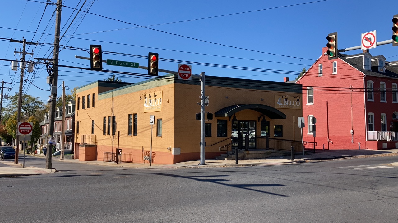
Now a credit union, this building on S. Duke St. in Lancaster once housed the Conestoga Elks lodge Benevolent Protective Order of Elks of the World (IBPOEW). The IBPOEW is an Black fraternal order modeled on the Benevolent and Protective Order of Elks, a fraternal group then open only to membership among White people.
NTHP hired a team of consultants to develop and execute a crowdsourcing platform and survey to identify places within that 7-county region associated with African American history and culture. The crowdsourcing platform, which used a custom WikiMap, was paired with public meetings to encourage participation and raise awareness about the project. Survey work was completed using Surveyor to add new places to PA-SHARE.
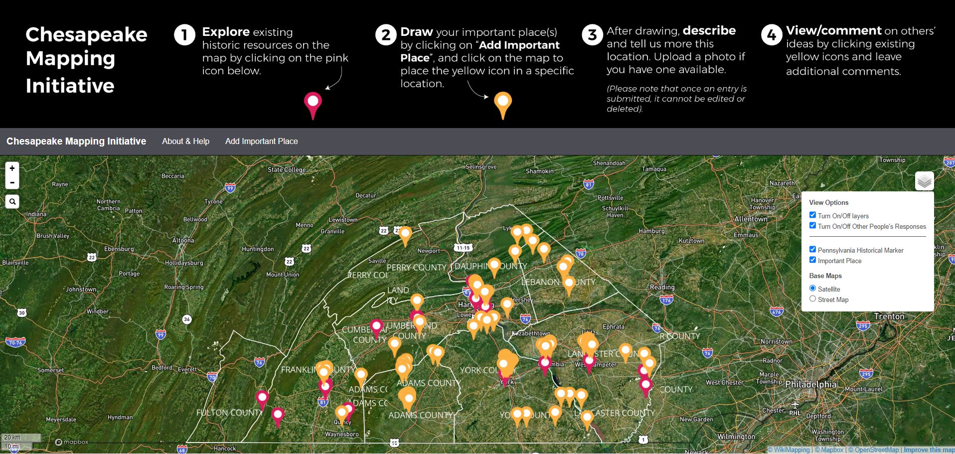
The Chesapeake Mapping Initiative wikimap gave users the opportunity to mark places associated with African American history and add comments. The yellow dots represent added content.
Members of the public contributed over 200 entries to the WikiMap. Knowledgeable local experts contributed their time and expertise to this National Trust project and without their assistance, the project wouldn’t have been able to capture as much information as it did. PA SHPO appreciates their time and contributions.
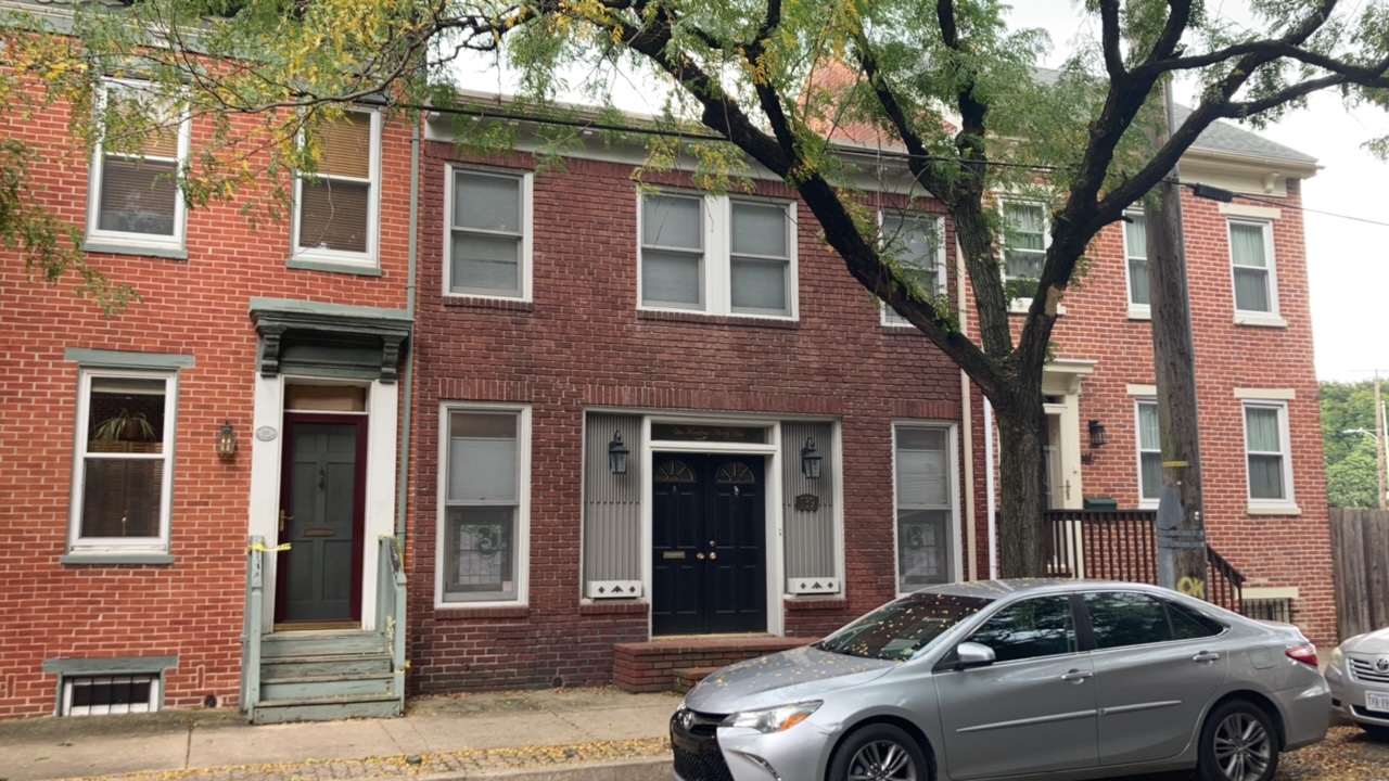
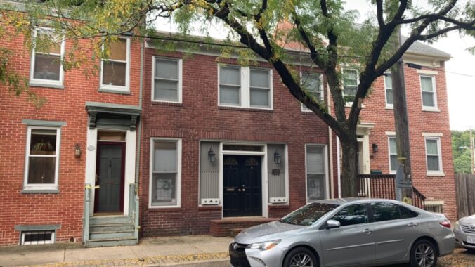
The International Athletic Club is one of the many places in York identified through NTHP’s crowdsourcing effort. This club was started in 1954 by Black Olympian John Terry, a weight lifter and boxer who competed in the 1936 summer Olympics in Berlin.
Of the 200+ identified locations, the consultant team identified 126 places for additional work: 52 places and six historic districts were surveyed and added as new resources to PA-SHARE, 47 places and six historic districts had existing records in PA-SHARE and these records were updated with this new information, and 15 were identified as potential archaeological sites.
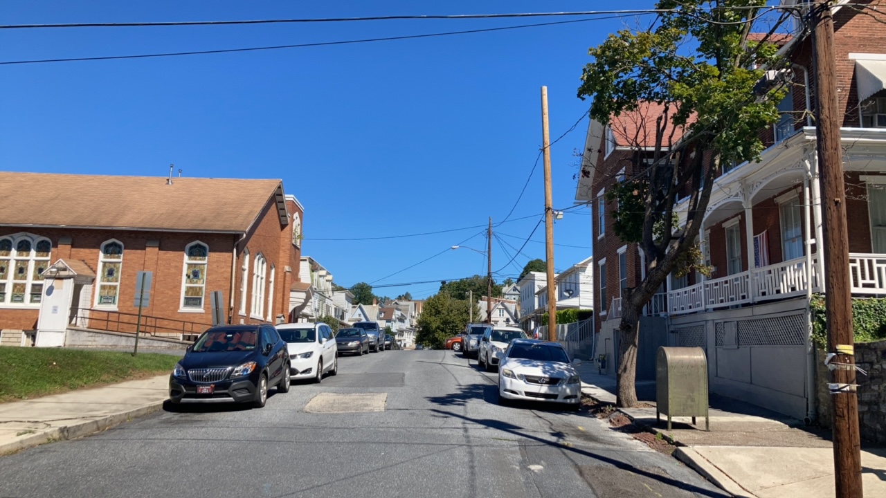
Judytown in Steelton Borough, Dauphin County was one of the six potential historic districts identified through NTHP’s project.
Following is a table of the buildings and historic districts that were surveyed or supplemented from crowdsourced contributions. If you are curious about any of these places and would like to learn more, you can search for them by resource name in PA-SHARE following these steps (more detailed search instructions are available on PHMC’s website):
- Go to https://share.phmc.pa.gov/pashare/landing. If you already have a PA-SHARE account, sign in. If you don’t, click “Register for an Account” to quickly create a free Basic account from the PA-SHARE landing page. If you don’t want to create a free account, click “Proceed as Guest” and follow the instructions. Please note that Guest and Basic users have limited data views and access to attachments.
- Once in PA-SHARE, click on “Search” near the upper left corner of your monitor. Search will open the “Quick” search fields by default on the left side of your monitor.
- Find “Resource Name” about halfway down the list.
- Copy the resource name from the table below and paste it into the “Resource Name” field.
- Click Search.
- All resources that match that that name will appear in the results grid below the map. Select the resource in the grid and click on the GoTo icon to open the resource record.
Note: There may be instances where you’ll see several places listed in the grid with that resource name. If that occurs, scroll down to the end of the grid results and select the place that has the same municipality and county shown in the table below.
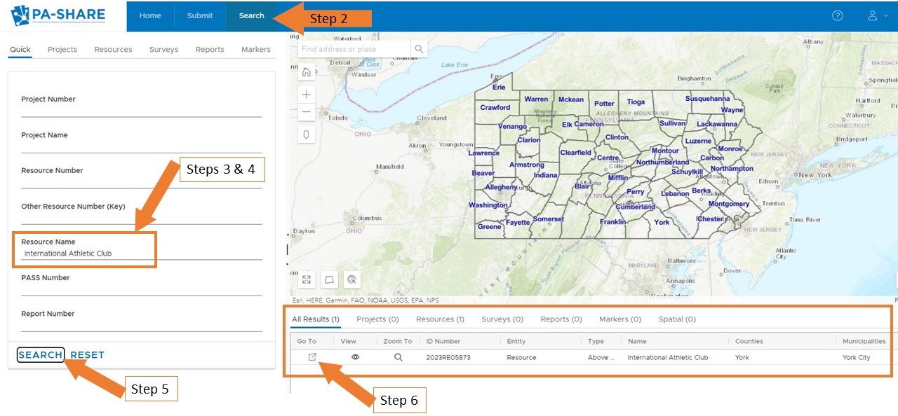
Steps for searching PA-SHARE for resources documented through NTHPS’s Chesapeake Mapping Initiative.
Chesapeake Mapping Initiative: Field Surveyed Properties in Pennsylvania
| Resource Name | Address | Municipality | County |
|---|---|---|---|
| Abraham Brian Farm | Hancock Avenue | Cumberland Township | Adams |
| Gettysburg Hotel | 1 Lincoln Square | Gettysburg Borough | Adams |
| Herrigan House | 428 S. Washington Street | Gettysburg Borough | Adams |
| Armstrong House | 226 Lincoln Lane | Gettysburg Borough | Adams |
| Becker House and Store | 245-249 S. Washington Street | Gettysburg Borough | Adams |
| 137 South Washington Street | 137 South Washington Street | Gettysburg Borough | Adams |
| 256 South Washington Street | 256 South Washington Street | Gettysburg Borough | Adams |
| 268 South Washington Street | 268 South Washington Street | Gettysburg Borough | Adams |
| 270 South Washington Street | 270 South Washington Street | Gettysburg Borough | Adams |
| 414 South Washington Street | 414 South Washington Street | Gettysburg Borough | Adams |
| Clay House | 85 West Stevens St | Gettysburg Borough | Adams |
| Devan House | 415 S. Washington Street | Gettysburg Borough | Adams |
| Dr. Basil Biggs House | 155 S. Washington Street | Gettysburg Borough | Adams |
| Drowry House | 124 West Middle Street | Gettysburg Borough | Adams |
| Erb House | 210 W. Middle Street | Gettysburg Borough | Adams |
| Foster House | 135 West High Street | Gettysburg Borough | Adams |
| Gantz House | 261 S. Washington Street | Gettysburg Borough | Adams |
| Hankey's Grocery Store | 201 S. Washington Street | Gettysburg Borough | Adams |
| Herrigan House | 344 S. Washington Street | Gettysburg Borough | Adams |
| Hopkins House | 219 S. Washington Street | Gettysburg Borough | Adams |
| Jackson House | 320 (326) S. Washington Street | Gettysburg Borough | Adams |
| Jenkins House | 215 W. High Street | Gettysburg Borough | Adams |
| King House | 315 S. Washington Street | Gettysburg Borough | Adams |
| Mathews House | 211 S. Washington Street | Gettysburg Borough | Adams |
| McGee/Penn House | 231 W. High Street | Gettysburg Borough | Adams |
| Roberts House | 253 S. Washington Street | Gettysburg Borough | Adams |
| Smith House and Garage | 241 S. Washington Street | Gettysburg Borough | Adams |
| Thomas House | 225-227 W. High Street | Gettysburg Borough | Adams |
| Third Ward Historic District | Gettysburg Borough | Adams | |
| Huntington Friends Meeting House | 300 Quaker Church Road | Latimore Township | Adams |
| Menallen Friends Meeting House | 1107 Carlisle Road | Menallen Township | Adams |
| Cyrus Griest Farm | 370 Quaker Valley Road | Menallen Township | Adams |
| Gettysburg Battlefield Historic District | Mount Joy Township, Highland Township, Mount Pleasant Township, Cumberland Township, Straban Township, Gettysburg Borough, Freedom Township | Adams | |
| St. Paul AME Zion Church | Adams | ||
| Philadelphia & Columbia Railroad | Multiple | Chester, Lancaster, Montgomery, Delaware, Philadelphia |
|
| Cumberland County Courthouse | 2 Court House Square | Carlisle Borough | Cumberland |
| Pine Grove Furnace | Cumberland | ||
| Brown House | 267 Briggs Street | Harrisburg City | Dauphin |
| First Zion AME Church | Middletown Borough | Dauphin | |
| Judytown | Steelton Borough | Dauphin | |
| Midland Cemetery | 206 Kelker Street | Swatara Township | Dauphin |
| Mary Ritner's Boarding House | 225 East King Street | Chambersburg Borough | Franklin |
| Lebanon Cemetery | Chambersburg Borough, Hamilton Township | Franklin | |
| Caledonia State Park: Office Building | PA 233 | Greene Township | Franklin |
| St. Paul AME Church | 30 West King Street | Waynesboro Borough | Franklin |
| Christiana Machine Company | 11 Green Street | Christiana Borough | Lancaster |
| Zion Hill | Columbia Borough | Lancaster | |
| First National Bank | 170 Locust Street | Columbia Borough | Lancaster |
| Columbia Historic District | Columbia Borough, West Hempfield Township | Lancaster | |
| Fulton Opera House | 12 N Prince St. | Lancaster City | Lancaster |
| Lancaster County Courthouse | 43 E King St. | Lancaster City | Lancaster |
| National Caramel Company Factory | 453 S Lime St. | Lancaster City | Lancaster |
| Crispus Attucks Community Center | 404 S. Duke Street | Lancaster City | Lancaster |
| Trinity Lutheran Church | 31 S. Duke Street | Lancaster City | Lancaster |
| Lydia Hamilton Smith House | 23 E. Vine Street | Lancaster City | Lancaster |
| Charles Moton House | 515 Howard Avenue | Lancaster City | Lancaster |
| Saint James Episcopal Church | 103 N. Duke Street | Lancaster City | Lancaster |
| Lancaster YWCA | 110 N. Lime Street | Lancaster City | Lancaster |
| Barney Ewell Park | 446 S. Christian Street | Lancaster City | Lancaster |
| Barney Ewell Plaza | 123 N. Queen Street | Lancaster City | Lancaster |
| Conestoga Elks | 452 S. Duke Street | Lancaster City | Lancaster |
| Dr. Copper House and Office | 420 S. Duke Street | Lancaster City | Lancaster |
| Mr. Vic’s Family Styling | 442 S. Duke Street | Lancaster City | Lancaster |
| Polite Family Home | 540 North Street | Lancaster City | Lancaster |
| Shreiner-Concord Cemetery | 242 W. Chestnut Street | Lancaster City | Lancaster |
| Thaddeus Stevens House and Office | 45 S. Queen Street | Lancaster City | Lancaster |
| Urban Redevelopment in Southeast Lancaster | S. Duke Street | Lancaster City | Lancaster |
| S. Duke Street African American Commercial District | Lancaster City | Lancaster | |
| Stevens Greenland Cemetery | 1000 S. Duke Street | Lancaster Township, Lancaster City | Lancaster |
| Lancaster City Historic District (additional documentation) | Lancaster Township, Lancaster City, Manheim Township | Lancaster | |
| Stone Arch Bridge | E. of Green Street | West Sadsbury Township, Christiana Borough | Lancaster |
| Anthracite/Goosetown | Cornwall Borough | Lebanon | |
| Ono Cemetery | 27 Main Street | East Hanover Township | Lebanon |
| St. John’s AME Church | 1244 Walnut Street | Lebanon City | Lebanon |
| Cumberland Street Historic District | Lebanon City | Lebanon | |
| Washington Street Neighborhood | Lebanon City | Lebanon | |
| Mount Lebanon Cemetery | 235 Maple Street | North Lebanon Township, Lebanon City | Lebanon |
| Fawn AME Zion Church Cemetery | 177 Alum Rock Road | Fawn Township | York |
| Fawn AME Zion Church | 177 Alum Rock Road | Fawn Township | York |
| Truman Fells Farm | 19022 Five Forks Road | Hopewell Township | York |
| Mt. Olive Cemetery/River Hills Cemetery | Lower Chanceford Township | York | |
| Chanceford AME Church Cemetery | Fulton Road | Lower Chanceford Township | York |
| Schley Alley Cemetery | Schley Alley / Pump Street | Manchester Township, North York Borough | York |
| Redlands Friends Meeting House | 700 Old Quaker Road | Newberry Township | York |
| Baptiste Farm | Newberry Township | York | |
| Joseph Garretson Farm | Newberry Township | York | |
| Lebanon Cemetery | North York Borough, Manchester Township | York | |
| Trinity AME Zion Cemetery | Pikes Peak Road | Peach Bottom Township | York |
| York Historic District | Spring Garden Township, York City | York | |
| Mt. Pisgah Burial Grounds/Stone Church Cemetery | Wrightsville Borough | York | |
| 1897 Iron Bridge Piers | Susquehanna River | Wrightsville Borough, West Hempfield Township | York |
| Beth Israel Synagogue/Holy Chapel Church of God in Christ | 129 S. Beaver Street | York City | York |
| 48 E Market St. | 48 E Market St. | York City | York |
| 116 E King St. | 116 E King St. | York City | York |
| Goodridge Freedom Center and Underground Railroad Museum | 123 East Philadelphia Street | York City | York |
| William Penn Senior High School | 101 W College Ave | York City | York |
| Bethel AME Church | York City | York | |
| 105/107 South Duke Street | 105/107 South Duke Street | York City | York |
| 221 E. King Street | 221 E. King Street | York City | York |
| Bracey House | 215 S. Penn Street | York City | York |
| Chapman House | 135 S. Queen Street | York City | York |
| Crispus Attucks Community Center | 605 S. Duke Street | York City | York |
| Dr. Bowles House | 145 S. Duke Street | York City | York |
| Emmanuel Church of God in Christ | 825 E. Princess Street | York City | York |
| Goodridge Barber Shop | 106 (110) N. Duke Street | York City | York |
| International Athletic Club | 139 S. Newberry Street | York City | York |
| Robinson House | 457 Salem Avenue | York City | York |
| Shiloh Baptist Church/Truth Tabernacle Seventh Day Adventist Church | 617 E. Princess Street | York City | York |
| Stephens Agency | 250 S. Harrison Street | York City | York |
| Voni B Grimes Gym | 125 E. College Avenue | York City | York |
| Frey’s Avenue Redevelopmemt | York City | York |
Leave a Reply