Historic resources inform citizens of their unique local heritage, cultural identity, and the origins of their community. They are the corner stones of our built environment and they provide a “sense of place”. In the aftermath of a disaster, these buildings, structures, objects, and sites are often associated with the very memories and connections that a community needs to begin to rebuild.
Preserving these historic resources is crucial to sustaining the quality of life that Pennsylvania residents enjoy, and it is imperative they remain a part of the landscape for present and future generations. With the threat of natural disasters increasing throughout the Commonwealth, the Pennsylvania State Historic Preservation Office (PA SHPO), a bureau of the Pennsylvania Historic and Museum Commission (PHMC), is leading the vanguard on preserving our historic communities by integrating sensitive hazard mitigation techniques.
The PA SHPO is at the forefront of this emerging field, with only a handful of other jurisdictions incorporating preservation into hazard mitigation planning. Phase II of the Disaster Planning for Historic Properties Initiative is well under way, and all of us here at Vision Planning and Consulting (VPC) in Columbia, MD are excited to be part of it.
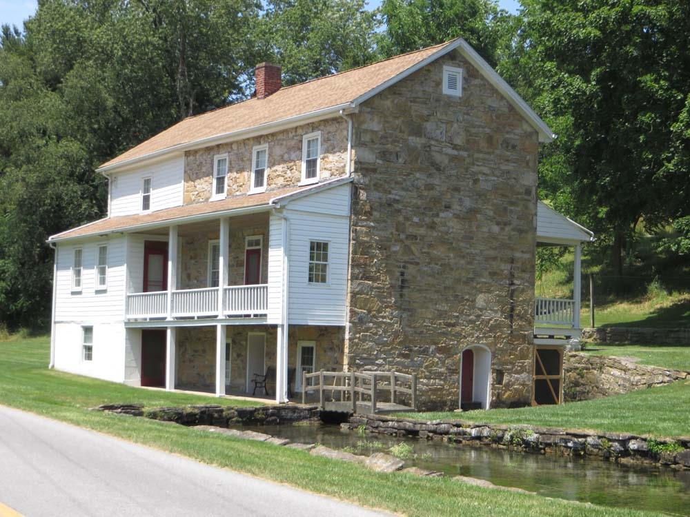
This property, identified in the study, shows how an architecturally interesting property can be a contributing property in a community. This stone residence in Bedford County (Key #011816) is a fine example of early stone masonry, and the stream, which was intentionally diverted into the basement of the home to be used as a spring house.
Phase II is the continuation of a pilot project conducted in Bedford, Cameron, and Monroe Counties and the City of Philadelphia. As mentioned in our post from February of 2015, these counties were ideal partners in the project due to their geographic and demographic diversity. The four participating jurisdictions range from densely populated, urban, and flat terrain, to very rural, sparsely populated, and rolling to mountainous terrain. Additionally, all four counties received Presidential Disaster Declarations following Hurricane Sandy. This diversity of size, population, and location makes this exercise applicable to every community in the Commonwealth.
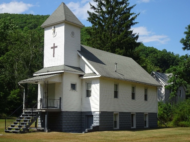
The rural Cameron County church (Key #905015.0001) is a fine example of a building that holds no National Register significance, however has local historical and sentimental value. The church is considered an important community landmark in the Village of Cameron, and highlights the importance of public outreach and stakeholder engagement in the historic inventory process.
What work does Phase II include?
Phase I was comprised of field surveys that identified which registered historic properties fell within the 100-year floodplain and captured elevation measurements for those properties. Phase II builds upon this analysis and consists of:
- 1) a GIS analysis and risk assessment (to identify the potential depth of flooding these properties could expect)
- 2) hazard mitigation action development (so as to not affect the historic character or integrity of the building)
- 3) a plan integration exercise (to identify gaps in plans and ordinances and develop recommendations for inclusion of historic preservation considerations)
- 4) a new historic preservation element which will be included in PEMA’s All-Hazard Mitigation Planning Standard Operating Guide (SOG)
Phase II began with a risk assessment which used the building footprint files and 1% chance (100-year) flood depth grids developed during Phase I. The buildings’ foundation elevation, lowest adjacent grade, and overall property elevation were also incorporated into the analysis which generated estimated first floor flooding depths for the properties identified in Phase I. Additionally, using the Army Corps of Engineers Economic Guidance Memorandum (EGM) 04-01, Generic Depth-Damage Relationships for Residential Structures with Basements, VPC was able to develop base level damage financial estimates for some of the properties.
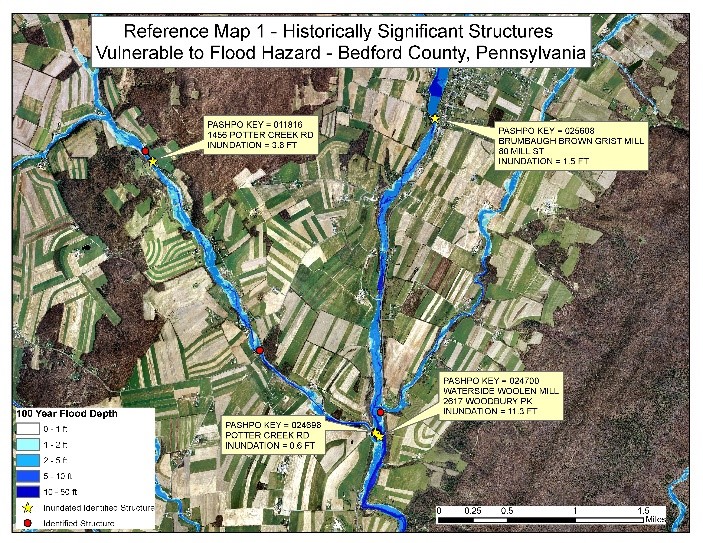
This sample flood map shows depth of flood estimates and locations of historic properties in select portions of Bedford County. GIS analysis of Bedford County identified several areas that showed clusters of inundated properties as shown in this sample.
Approximately 150 properties have been identified across the four study areas as case study properties, based on GIS analysis, which examined the inventory generated during the 2016 Phase I Reconnaissance Survey. Historic buildings in the 100-year floodplain that are at higher risk from flooding were assessed based on the financial estimates, flood depth estimates, and further evaluated, based on architectural criteria such as building and structural variety, historic significance, and architectural merit. The analysis generated the final list of the 150 “representative” properties for the three counties and City of Philadelphia.
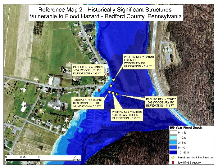
This map shows a different grouping of historically significant structures vulnerable to flood hazards in Bedford County. These buildings showed ranges of flooding from as little as six inches to over 10 feet in some particularly at-risk buildings, such as the Waterside Woolen Mill in South Woodbury Township.
How will this information be used?
The estimates of expected flood depths for the selected buildings will enable VPC to develop property-specific mitigation actions to help protect each historic property from flood damage, without risking the building’s integrity or eligibility for the National Register of Historic Places.
There are significant benefits that come with listing on the National Register. By maintaining its eligibility, a site is eligible not only for tax credits, but also qualifies for preservation grants and awards. Coupling these benefits with the potential for tax deductions for charitable conservation contributions and additional funding, including loans, provides definite economic benefit to historic register listing.
In addition to the financial aspects, there are numerous intangible benefits to maintaining the largely honorific listing. Historic properties and districts:
- help drive tourism in local communities; provide real world educational resources,
- encourage property maintenance and upkeep in areas adjacent to or even outside of the historic district,
- help promote job creation in preservation fields,
- promote a sense of pride and unity within the community.
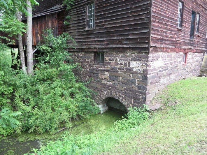
This example of an “at risk” property in Bedford County has a stream that flows directly under the building. Proper maintenance and care of the stone masonry will help ensure structural integrity and prevent collapse.
One of the primary goals of the project is to develop site-specific mitigation actions that do not disturb the very qualities and characteristics of a building that made it special, and eligible for historic listing, in the first place. Actions such as replacing windows and doors could diminish the overall integrity of the building if not done sensitively. Additionally, elevating a building may affect its design, setting, or feel.
The big question is: “How do we protect properties without modifying them beyond the scope of the Secretary of the Interior’s (SOI) Standards for the Treatment of Historic Properties, and thus rendering them ineligible?”
What is next?
Our next step is to develop a list of preservation-sensitive hazard mitigation actions for the 150 representative properties selected during the risk assessment phase. These mitigation actions could include building modifications to help protect the building while ensuring that it remains eligible for historic listing. Additionally, these actions will be applicable to other buildings of similar age, style, and construction throughout the Commonwealth.
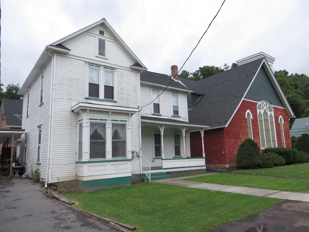
This “at risk” historic home shows signs of deterioration at the foundation, which will allow floodwaters to enter the crawl-space. Some areas are in need of repainting to keep the exterior envelop water resistant.
The final report will provide property owners with an assortment of building forms, styles, and conditions to help them determine the most appropriate mitigation actions to protect their buildings from hazards while maintaining historic integrity.
What kinds of actions are appropriate?
Some hazard mitigation actions are appropriate so long as they do not severely alter the façade of the historic building. Actions such as elevation can be completed successfully if steps are taken to minimize the visual impact of the mitigation measure. One such minimization measure is strategic landscaping to hide the new building elevation. Although there is a moderate elevation difference between the two examples shown below, the house on the left has a much more severe visual impact than the “camouflaged” elevation of the house on the right.
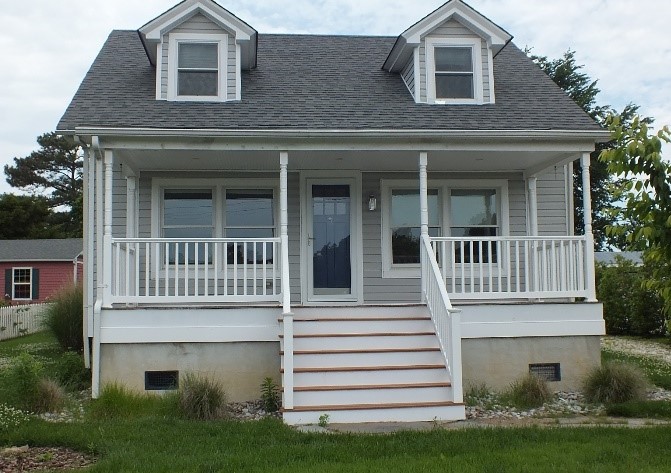
Elevated house without landscaping shows raised foundation as a flood mitigation.
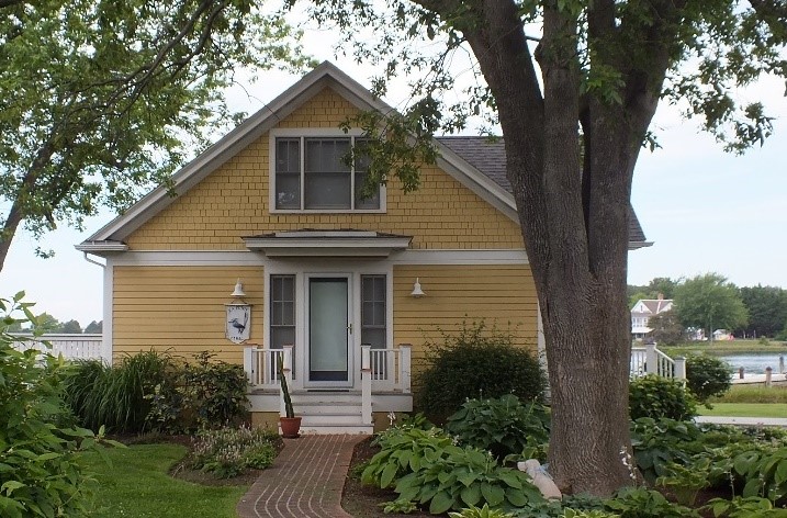
The landscaping around the foundation of this elevated house hides the unattractive raised foundation.
Additional actions can be taken that effect the building minimally if at all. From a historic preservation standpoint, actions that do not touch the building are preferable to actions that touch or modify the building itself. Simple actions such as elevation of fuel tanks and utilities can help immensely and are less likely to affect the integrity of the historic property. Additional benefits of utility elevation include reduced risk of fire, so long as all electrical lines, connections, wiring, and outlets are raised above the base flood elevation. Minimization measures such as landscaping, discussed above, can also be used to hide elevated utilities. In some instances, a cabinet or structure can be built to house the utilities so long as the materials and ornamentation of the structure reflect a context-sensitive design.
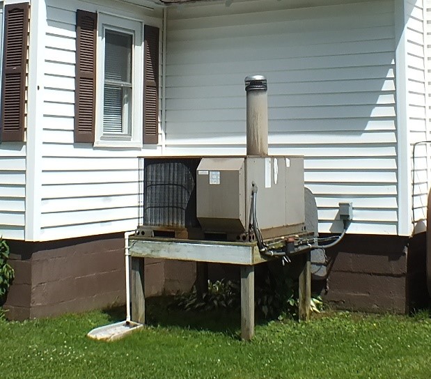
Elevating utilities can provide many benefits.
A final example of recommended mitigation actions is a temporary action. These can be preferable to permanent actions as they don’t alter the integrity of the property if they don’t touch the building. Examples include sandbagging below grade openings, constructing temporary floodwalls, or building berms around an at-risk property.
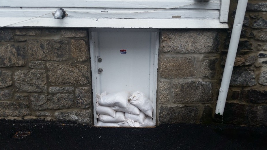
Communities may build temporary sandbag barriers along roads or waterways. Property owners can also use sandbags at below-grade openings to restrict or stop floodwater.
What else is happening?
Another exciting feature of this project will be flood-depth visualizations generated for the case study properties in each of the study areas. This will provide property owners a sense of estimated flood levels for both the subject buildings and similar properties.
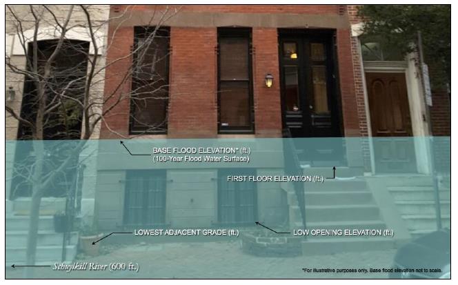
As evident in this example, the entire basement level of this townhome is completely inundated, and the first floor of the residence shows over a foot of flooding.
Examining parts of the buildings or structures that are at risk will help guide the mitigation action development process, provide property data on what to expect in the wake of a 1% chance flood event, and show a visual of what would be flooded.
How can I learn more?
Public open houses will be held in each county to solicit input on local historic treasures and guide mitigation action development. Bedford County’s meeting was held on November 1st, 2017, but additional feedback is welcome by phone or email. Philadelphia’s public meeting is tentatively scheduled for December 2017, and the Cameron and Monroe County meetings will be scheduled for early 2018. Be sure to follow PHMC on Facebook, Twitter, and this blog for updates throughout the Phase II process and for meeting information.
If you are interested in attending your local meeting, or if you have any questions about the project, please email jgardosik@pa.gov or call 717.787.0771 for more details.
Stayed tuned to the PHMC Blog for more updates on the exciting and ongoing efforts across the Commonwealth!
This week’s post was written by Ashley Samonisky of Vision Planning & Consulting, LLC. Ms. Samonisky is a project manager and lead planner for Vision Planning and Consulting. She has over seven years of emergency management and planning experience including: hazard mitigation, preparedness planning, GIS, public outreach and education. She serves as project manager on cultural resource/hazard mitigation projects. Ms. Samonisky prepares mitigation, preparedness, and recovery plans for communities throughout the Mid-Atlantic. Ms. Samonisky received her Bachelor’s in Emergency Management from Maryland and completed a second Bachelor’s from Salisbury University in Geography. She currently serves on the Maryland State Geographic Information Committee (MSGIC) as the Outreach Sub-Committee Chair.
Comment Policy
PHMC welcomes and encourages topic-related comments on this blog. PHMC reserves the right to remove comments that in PHMC’s discretion do not follow participation guidelines.
Commenters and Comments shall be related to the blog post topic and respectful of others who use this site.
Commenters and Comments shall not: use language that is offensive, inflammatory or provocative (this includes, but is not limited to, using profanity, obscene, or vulgar comments); disparage other commenters or people; condone illegal activity; identify the location of known or suspected archeological sites; post personal information in comments such as addresses, phone numbers, e-mail addresses or other contact details, which may relate to you or other individuals; impersonate or falsely claim to represent a person or an organization; make any commercial endorsement or promotion of any product, service or publication.
If you would like to comment on other topics not related to this blog post but related to PHMC, please fill out the PHMC Contact Us Form.
Leave a Reply