Pennsylvania Historic Preservation

Blog of the Pennsylvania State Historic Preservation Office

Page 41 of 74

Protecting against Future Floods: Floodproofing Workshops in PA

During the week of August 13th, The Pennsylvania Silver Jackets hosted floodproofing workshops in York, Lewisburg, and Wellsboro, and the State Historic Preservation Office had a representative (me) there to answer questions from public officials and members of the public.

Now I’m sure you have a lot of questions. What are Silver Jackets? Why was PA SHPO there? What are Flood Proofing Workshops? These are all excellent questions; let’s address them one at a time and look at some example of real-life flood proofing projects and their effects on historic resources.

Pennsylvania Silver Jackets

To quote the Silver Jackets website, the “Pennsylvania Silver Jackets is an interagency team dedicated to working collaboratively with the commonwealth and appropriate stakeholders in developing and implementing solutions to flood hazards by combining available agency resources, which include funding, programs, and technical expertise.”

Silver Jackets – multiple agencies, one solution!

Why the name? Different agencies have specific colors they use for their jackets during emergency response (think blue FEMA jackets after Hurricane Katrina), but nobody had yet claimed silver, so it serves as a unifying color for all agencies. Every state except for Hawaii has a Silver Jackets team, and Pennsylvania’s meets quarterly in Harrisburg to plan outreach and discuss project opportunities.

Community outreach is one of the Silver Jackets’ priorities.

Flood Proofing Workshops

Each day included two workshops – one in the afternoon for public officials and one in the evening for members of the public.

People sitting at tables

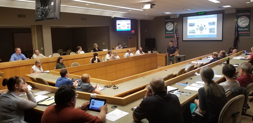
Floodproofing workshop in Lewisburg, Union County, on August 15, 2018.

In the world of emergency management, floodproofing measures are a subset of hazard mitigation and are divided into two general categories: structural and non-structural. These workshops focused on non-structural floodproofing methods. Somewhat confusingly, “non-structural” floodproofing measures include lots of projects that directly affect, alter, move, or even demolish existing structures.

Structural floodproofing includes projects that involve building something new, such as a dam or levee, while non-structural floodproofing includes projects that include no construction or alterations to existing buildings. Basically, non-structural floodproofing includes everything than an individual property owner can do to her property.

This can include planning, relocating utilities above projected flood levels, filling in a basement, elevating, or even relocating a building to remove it from flood risk.

Hufnagle Park in Lewisburg, PA

While in Lewisburg, I had some time between meetings to explore the borough (and look for something to eat.) Walking down Market Street, I passed Hufnagle Park and saw families strolling along a stream. As it turns out, this park is an example of a large hazard mitigation project to reduce flood risks by increasing open space along the stream.

Stream in a park

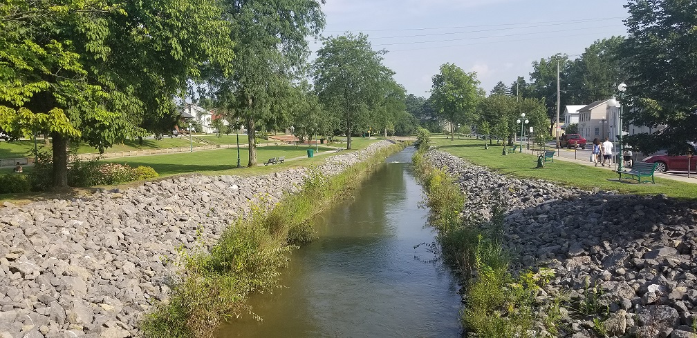
Looking southeast along Bull Run in Lewisburg, PA in August 2018.

The Borough of Lewisburg collaborated with Bucknell University in 2004 to produce The Lewisburg Neighborhood Project, a plan to address a range of concerns including student housing availability and flood hazards. One of the central projects in the plan was the Bull Run Greenway, a system of parks, trails, and green spaces along a stream that runs through the borough.

In 2012 the Borough used federal funds to purchase and demolish ten private properties on 6th Street southwest of Bull Run that were at heightened risk of repeated flooding. These buildings were within the Lewisburg Historic District, so mitigation of this project was required in the form of recordation of the to-be-demolished buildings and their immediate context. In the photo above, the demolished structures would have been visible on the right-hand side. Below are some example photos provided in the recordation package.

Two story house

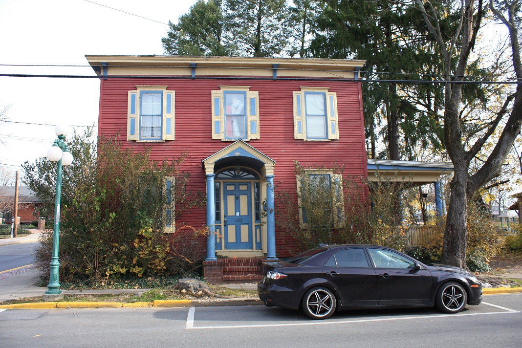
Lewisburg’s 102 South 6th Street in 2012, now demolished.


Two-story house

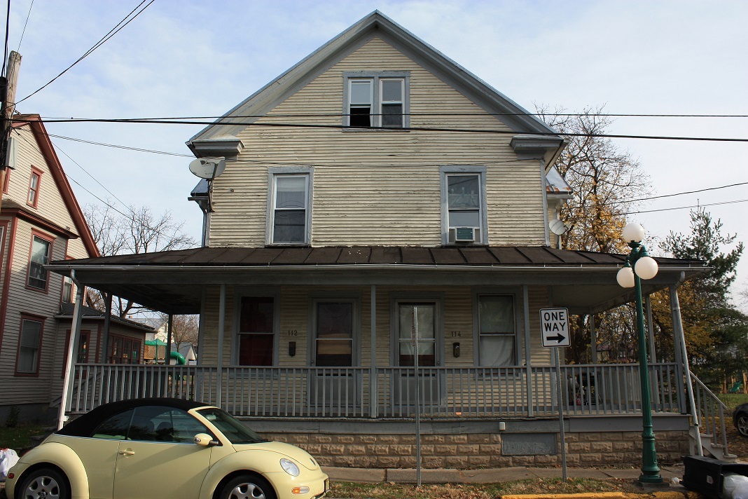
Lewisburg’s 112 & 114 South 6th Street in 2012, now demolished.

This type of project is often referred to as “demolition-acquisition”, and it is perhaps the most permanent form of hazard mitigation that FEMA funds. No funds will ever have to be spent on these properties again, and, by converting the land to permanent open space, surrounding properties could benefit as well. When a property is acquired using FEMA funds, it is required to remain open or park space in perpetuity. The next time it floods, water from Bull Run will have a little more space to flow and might not have as much of an impact on the houses across the street. Of course, ten buildings are now gone forever.

Peer State Example

There are hazard mitigation measures that can have less of a negative impact on historic buildings, but sometimes they require an extra level of creativity to balance hazard mitigation requirements with historic integrity.

As an example from outside of the commonwealth, new owners of the old Spaghetti Warehouse building in Houston, Texas are embarking on major rehabilitation project. The building is a contributing resource in the Main Street Market Square Historic District, but it backs up to Buffalo Bayou and was damaged by Hurricane Harvey.

As shown in the rendering below, the project would actually open the building up to water; in future floods, the bayou will be able to flow right through the back and side wall. The only fully enclosed and condition space will be on the second floor, and even that will be set back from the two newly opened walls.

Drawing of two-story brick building

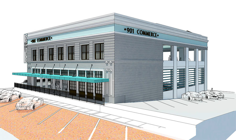
Rendering of proposed changes to 901 Commerce; Houston Planning and Development.

Despite these changes, the owner intends to make full use of 901 Commerce with a bar on the second floor and market space on the first floor and basement. Food trucks will even be able to pull directly into the basement. This is, of course, a pretty extensive alteration to this building, but it might provide a thoughtful alternative for how to live with water without losing our built heritage.

And that brings us back to three days of workshops in central Pennsylvania. Bull Run flooded in 2011 in Lewisburg, and Houston is still recovering from Hurricane Harvey, so flooding remains front of mind.

Flooding is not a constant problem in most of our communities, but it is a continuous one. In times between disasters (what emergency managers refer to as “blue sky”), it’s easy to fall into familiar practices and forget to prepare for future flooding.

These three workshops happened to coincide with weeks of record rainfall in central PA, but even if they hadn’t, they were intended to remind people who the risk of flooding is not going away. Whether you own a home that might be damaged, or work for an agency or local community, there are things you can do to help safeguard against the next flood, and there are people and agencies available to answer questions and provide assistance.


John Gardosik is the Hurricane Sandy Recover Project Manager at the Pennsylvania State Historic Preservation Office. Though new to Pennsylvania, he is married to a Lancaster native and is enjoying getting to know the Commonwealth.

5 Things to Do on Pennsylvania’s West Branch Susquehanna Byway

Are you looking for an adventure?  Then take a drive to Clearfield County because Pennsylvania’s West Branch Susquehanna Byway is an adventure that awaits you at every turn.

What is a Pennsylvania Byway?

The Pennsylvania Department of Transportation (PennDOT) established the Pennsylvania Byways (PA Byways) program in 2001 to identify and designate corridors with cultural, historical, recreational, archaeological, scenic, and natural qualities and outstanding features throughout the commonwealth.

Sign with flower

If you see one of these, check it out!

PennDOT’s mission for this program is to:

  • support communities and local governments in achieving byway designations,
  • assist with local planning efforts to maintain byway resource qualities,
  • protect and preserve visual impacts,
  • educate residents and visitors,
  • promote tourism, and
  • enhance economic development potential throughout the commonwealth.

The PA Byways program parallels U.S. Federal Highway Administration’s National Scenic Byways Program, which was created in 1991 as part of the Federal Intermodal Surface Transportation Efficiency Act (ISTEA).  The main difference between the two programs is that Pennsylvania does not use “scenic” in its title, recognizing that many roadways exemplify more than purely scenic qualities.

Currently, Pennsylvania has 21 designated PA Byways, one National Forest Scenic Byway, and three National Scenic Byways, and one All-American Road.  The existing network of byways includes over 650 miles of roads through almost half of Pennsylvania’s 67 counties!

Map

Take some time to explore some of PA Byways.

**The Pennsylvania Byways program is currently being restructured. If you have interest in designating a byway, please contact Jacqueline Koons-Felion at jfelion@pa.gov or 717-787-6388.**

5 Things to Do and See along the West Branch Susquehanna Byway

1. The Drive

The West Branch Susquehanna Byway offers seventy-two miles of winding roads showcasing historic, archeological, cultural, recreational, natural and scenic rarities that are inherent of Clearfield County. This byway is a great outlet for the outdoorsman, civil war buff, foodie, photographer, and the explorer.

PennDOT designated this corridor as Pennsylvania’s 19th Byway in March 2012.

Map

Got to www.visitclearfieldcounty.org for more information!

The West Branch Susquehanna Byway is a scenic and natural beauty that is a must see. During the nineteenth and early twentieth centuries, the Susquehanna River was a lifeline of historic Clearfield County. The River served as the lumber transport system that fueled the once-booming economy. The byway was named after the river because of its historical significance, but also because the byway provides access to the abundance of recreational opportunities that the Susquehanna River offers, both on its banks and in its waters.

2. McGees Mills Covered Bridge

McGees Mills Covered Bridge

This Bridge is the only covered bridge crossing the mighty Susquehanna River and the only one still being used in Clearfield County. The 122 ft. single span Burr arch truss bridge was built in 1873 by Thomas A. McGee. Thomas built the bridge using hand hewed white pine timbers from the area and at a cost of $175. It was the last covered bridge built in Clearfield County. Thousands of rafts floated under the bridge including the last raft in 1938.

The bridge was listed on the National Register of Historic Places in 1980 and renovated in 1994 after a collapse caused by record-breaking ice and snow. This scenic spot remains one of the most popular photographic attractions in Clearfield County and is also located at the very beginning or end of the West Branch Susquehanna Byway.

3. Bilger’s Rocks

Rocks in mountain

Clearfield County’s Bilger Rocks

Over 300 million years ago, before the settlers, before the Indians, way back when the earth was taking its shape; a city was built just outside of Grampian in Clearfield County. This prehistoric city was like none other, for it was made of massive rocks. Twenty acres of massive rocks to be exact. Some of the rocks tower of five stories high and most of them are over 20 feet thick. The geological phenomenon responsible for this masterpiece is known as frost wedging. Frost wedging causes boulders to break away from the mountainside and helped create this magnificent vision full of numinous caverns and narrow passageways that has withstood eons of vagaries. There are 170 acres of park land where the Bilger’s Rocks Association offers campsites, pavilions, picnic area, a concert arena, recreational activities and even a concession stand that is open every weekend. www.bilgersrock.net

4. Curwensville Lake

Water and beach

Picturesque Curwensville Lake, Clearfield County.

Curwensville Lake is a reservoir located just to the south of the town of Curwensville. The lake was formed due to the construction of the Curwensville Dam to the north of the lake. Before the dam was built, there were several floods occurring along the West Branch Susquehanna River, affecting the towns of Curwensville, and Clearfield to the north. On September 3, 1954 a Flood Control Act was passed due to the flooding along the West Branch river basin. The dam cost $20,400,000 to construct. Curwensville Lake offers many opportunities to entertain the whole family. Biking, hiking, boating, camping and fishing are just a few of the activities available at Curwensville Lake. And with no horse power regulations on the lake, visitors can enjoy the open waters with their boat and spend some relaxing time catching some of the freshwater fish.

5. Denny’s Beer Barrel Pub

Food

Burger challenges at Denny’s Beer Barrel Pub.

Denny’s was founded by Denny and Jean Liegey in September 1977. Denny’s started making giant hamburgers to attract attention and to create a fun atmosphere for all. Denny’s is known nationally as the home of the “World’s Largest Hamburger Challenges.” It all started with a 2 lb. hamburger challenge with homemade buns baked in a coffee can and the rest is history. Denny’s became famous in 1998 for “The Ye Olde 96er” and have been featured on tv shows like Rachel Ray, The Food Network, Travel Channel, Good Morning America and many more. Guests have dined from all 50 states and many from countries around the world.

Interested in seeing and learning more?

The West Branch Susquehanna Byway is a beautiful scenic and fun byway. This is just a small taste of what the byway has to offer. Visit us in person or on our website, www.visitclearfieldcounty.org, to learn more about the West Branch Susquehanna Byway.


This week’s post is by guest contributor, Josiah Jones.  Josiah is the executive director of Visit Clearfield County. 


Things You Need to Know: Environmental Review Updates

There are always lots of “Things You Need to Know” in today’s world, and this week’s post features a few from our Environmental Review staff, Barbara Frederick and Doug McLearen.

Online Data Entry for Above Ground Resources

We’ve been talking about PA-SHARE for quite a while now, and we here at the PA SHPO have been changing how we operate to “model the work” to be ready when PA-SHARE is launched.  How newly identified resources are submitted for review is one of those things we’ve been changing.

As we announced in early July, submissions including 10 or more newly identified resources are required to be electronically entered into CRGIS. Data entry has been well received! Thank you!

We would also like to encourage those submitters sending in projects with fewer than 10 newly identified resources to use online data entry as well.

As outlined in the updated Interim Guidelines for Above Ground Environmental Review, the process is generally the same and only varies slightly depending on the number of resources being submitted. There is some greater flexibility in the submission process:

  • Submitters of less than 10 newly identified resources are to notify the appropriate above ground environmental reviewer when resources are ready for review and comment via email rather than by mail.
  • Also, a table of the results of the identification effort is not required when there are fewer than 10 newly identified resources; providing the project’s Environmental Review (ER) number and the names and key numbers of resources whose data entry has been accepted by CRGIS staff as part of request to review and comment is sufficient.

Archaeology for new cell towers

Example of a cell phone tower.

It is the PA SHPO’s position that the majority of proposed new cell tower sites in Pennsylvania are commonly located in areas where significant archaeological resources are not likely to be present. Exceptions to this pattern are:

  • when the Area of Potential Effect (APE) for direct effects is located on or adjacent to a previously recorded archaeological site, either pre-contact or historic; or

The APE is in a similar topographic setting as that of a previously recorded pre-contact archaeological site or otherwise associated with topographic and environmental factors that typically favor the locations of pre-contact sites; or

  • when the APE has a high probability of containing historic archaeological resources based on a historical association such as buildings shown a historic map, presence of historic buildings on-site, or location in a historic district.

The FCC Nationwide Programmatic Agreement (NPA) requires that their applicants’ submission packets provide a justification for a finding that no archeological survey is necessary. If results of a thorough desktop review are provided to our office, they must contain clear, descriptive information as to why it is unlikely that archaeological resources are present. If a field visit/ survey is also undertaken—which is usually the case–the packet should then present the results.

When no archaeological resources are found in a survey, and/or the entire APE for direct effects is found to be disturbed:

  • PA SHPO considers these surveys to constitute field checks rather than conventional Phase I archeological surveys. In these instances, the production of a full archaeology report will not be required. For convenience, however, the applicant should use the PA SHPO’s Negative Survey Form or, if more appropriate, the PA SHPO’s Record of Disturbance.

If a field survey does identify an archeological site within the APE for direct effects:

  • PA SHPO expects the applicant’s consultant to prepare a full Phase I archeological report in complete accordance with the instructions in Guidelines for Archaeological Investigations in Pennsylvania (PA SHPO 2016). The PA SHPO will then review and comment on the finding and continue to consult with the applicant on National Register eligibility and effects.

The PA SHPO forms and documents named above can be found on the PHMC web site at: https://www.phmc.pa.gov/Preservation/About/Pages/Forms-Guidance.aspx.

We know it can be hard to keep track of all these changes, so please give us a call or send us an email with any questions!

Doug McLearen, Division Chief, can help with archaeology-related questions:  dmclearen@pa.gov.

Barbara Frederick, Supervisor, can help with above-ground resources questions: bafrederic@pa.gov.

Summer 2018 PA Historic Tax Credit Update

After a chaotic winter where one of the federal government’s most successful historic preservation programs over the past 40 years – the Historic Preservation Tax Credit – was almost eliminated during federal tax reform, there is a lot to catch up on relating to both the federal and Pennsylvania historic tax credit programs. Continue reading

Metal Truss Bridges Survey Update: More Bridges Determined Eligible for the National Register of Historic Places

Metal truss bridges are an important part of Pennsylvania’s engineering and technological history and stand as a legacy to the state’s iron and steel industry. Continue reading

« Older posts Newer posts »
Wordpress Social Share Plugin powered by Ultimatelysocial