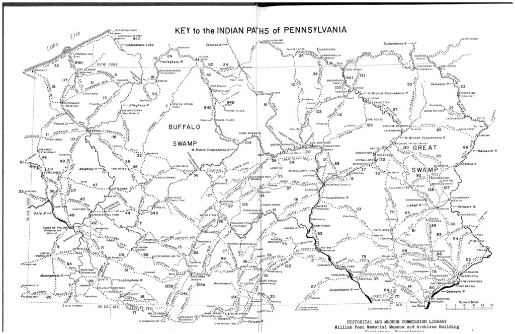
Recently, you may have noticed a new data set was added to CRGIS and you may be wondering what it is. This new data set appears to be several crisscrossing and winding paths – and they are!
These paths are the infamous “Indian Paths of Pennsylvania” as described by Paul A. W. Wallace in his book of the same name. This summer, two PennDOT interns, in collaboration with the PA SHPO, have revised data sets previously mapped by URS Corporation, Inc. and added these trails to CRGIS.

To do this, they utilized the shapefile created by URS and the Wallace Book descriptions of the paths. Since many of the paths no longer exist today, the two interns placed the them in a quarter mile buffer. This buffer approximates the location of the paths, allowing for error in the exact location.
Each path mapped on CRGIS has a pdf file attached to it. This file gives a summary of the entry for the path in the Wallace Book. This pdf includes historic accounts of the path, associated dates, Indian towns, historic towns, rivers, and more!

Notably, anything labeled “historic” in the entries refers to the 1965-era towns or resources referenced by Wallace in his book that existed in 1965 but may or may not exist today.
Also, of note, the associated dates and the historical accounts are those mentioned by Wallace and no additional research was done to add any new information to these historic accounts. If a path has multiple historic names, it is mentioned in the data record as well as the pdf. A few paths mentioned in the book, were not mapped into CRGIS because they either lacked a map in the Wallace Book or did not have enough descriptive information to map.
The paths were added to the layer called “Aggregate” since they are compilations of data and not actual resources. They each have an eligibility status of “Undetermined” because they are not a resource subject to National Register evaluation. During planning processes, they should be considered an indicator that resources may be present, similar to a high probability area.
If you have any questions or concerns, contact the CRGIS staff at the State Historic Preservation Office.
Comment Policy
PHMC welcomes and encourages topic-related comments on this blog. PHMC reserves the right to remove comments that in PHMC’s discretion do not follow participation guidelines.
Commenters and Comments shall be related to the blog post topic and respectful of others who use this site.
Commenters and Comments shall not: use language that is offensive, inflammatory or provocative (this includes, but is not limited to, using profanity, obscene, or vulgar comments); disparage other commenters or people; condone illegal activity; identify the location of known or suspected archeological sites; post personal information in comments such as addresses, phone numbers, e-mail addresses or other contact details, which may relate to you or other individuals; impersonate or falsely claim to represent a person or an organization; make any commercial endorsement or promotion of any product, service or publication.
If you would like to comment on other topics not related to this blog post but related to PHMC, please fill out the PHMC Contact Us Form.

Great post Noel. Explaining why SHPO uses “Aggregate” and “Undetermined” status is helpful for better understanding other data in SHPO files.
Any reason why they are described as “infamous” rather than simply “famous”?
Excellent question!
HI Noel,
Awesome!
I’m doing genealogical research on my ancestors who arrived in Pennsylvania in 1732. They purchased land in Lancaster and Dauphin Counties. I’ve been researching the ways in which they could have traveled to the tracts of land they purchased, i.e. roads and Indian paths. The map you have displayed using the information from Paul A. W. Wallace’s book is exactly what I’ve been looking for.
I’m working on my fourth “book” of my family’s ancestry. This is for my personal use only and as gifts to family members. Can you tell me where I might find a high resolution copy of the map? I would appreciate any help you can give me.
Perhaps I am just not seeing it, but is the public able to download a copy of the path data? An SHP file or the like? Something we could then import into QGIS for our own projects?
This was such an interesting read! I love how the Wallace Paths project highlights the importance of preserving not just the trails themselves but also the history behind them. It’s amazing how mapping can keep these stories alive for future generations.