We’ve been hard at work with PA-SHARE’s developers over the summer to continue to improve the user experience with PA-SHARE and Surveyor. Thanks to helpful feedback from PA-SHARE’s users, we’ve been able to make some useful enhancements and fix bugs in both applications.
Here are a few of the fixes and enhancements related to the external user experience since the last update in April 2022:
In PA-SHARE:
Pre-Contact Probability Model (PPM): Pro and Business users can now include the PPM layer in their spatial search exports. The map key for the PPM has also been fixed.
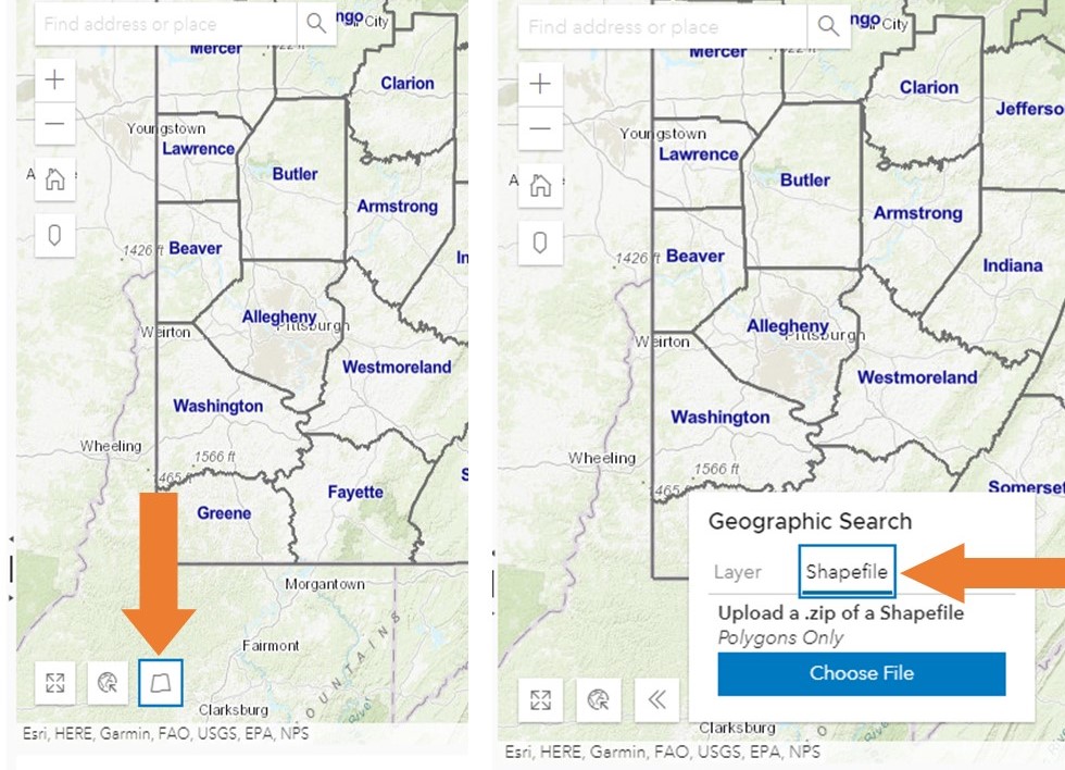
Search by Shapefile: Any user can now upload a shapefile to use as a boundary for a spatial search on the Search page. Search results will be returned for projects, resources, surveys, reports, and markers within that boundary.
To use this functionality, expand the “Geographic Search” option on the bottom left corner of the map screen. This widget automatically opens to the “Layer” tab so users will need to click on the “Shapefile” tab. You must upload a .zip archive of a shapefile using this tool. Click “Choose File” to select the shapefile you want to use for the search. Once successfully uploaded, the shapefile will appear as a hatched yellow feature on the map and the results will populate the results grid below.

New District Details: In addition to lots of data and presentation clean up, outbuildings and large and small landscape features can now be entered for historic districts. Pro, Business and Public Service users can view this in the historic district record under the “Details” tab. Basic and Guest users will see an abbreviated version of the summary tab.
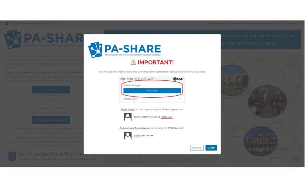
Enhanced Sign In Instructions: Additional instructions were added after the disclaimer to direct users to the correct sign in options. This helps eliminate confusion between the Enterprise and ArcGIS logins and the different Enterprise login options.

At-A-Glance Statistics: This useful information, which includes data about PA SHPO’s activities within the State Fiscal Year (SFY) and to date, is now located in two places: at the bottom of the PA-SHARE landing page (below the sign in) and at the bottom of the Home screen (below the blue boxes). Users will need to scroll down using the bar at the right side of the screen.
In Surveyor:
Additional Information At-a-Glance: In Surveyor Manager, additional data is now available on a survey’s overview page. Columns for address, county, municipality, and submitter recommendation have been added and the column for “Parent Survey” has been removed. Users can now sort and limit by these fields when working with their survey data.
More Data Fields: New optional fields have been added to the Surveyor forms to increase the type and amount of data that can be collected about a resource. These fields include ethnic affiliation, outbuildings, landscape features, small scale features, and recorder recommendation.
In addition to these new features and fixes, there has been a significant amount of work behind the scenes. We continue to improve how historic district data is organized and displayed, which you may have noticed if you look at district records frequently. We also address bugs and glitches to keep our project reviews and data management moving smoothly.
Comment Policy
PHMC welcomes and encourages topic-related comments on this blog. PHMC reserves the right to remove comments that in PHMC’s discretion do not follow participation guidelines.
Commenters and Comments shall be related to the blog post topic and respectful of others who use this site.
Commenters and Comments shall not: use language that is offensive, inflammatory or provocative (this includes, but is not limited to, using profanity, obscene, or vulgar comments); disparage other commenters or people; condone illegal activity; identify the location of known or suspected archeological sites; post personal information in comments such as addresses, phone numbers, e-mail addresses or other contact details, which may relate to you or other individuals; impersonate or falsely claim to represent a person or an organization; make any commercial endorsement or promotion of any product, service or publication.
If you would like to comment on other topics not related to this blog post but related to PHMC, please fill out the PHMC Contact Us Form.

Leave a Reply