By Jill Hall and Karen Marshall
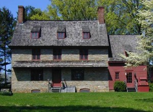
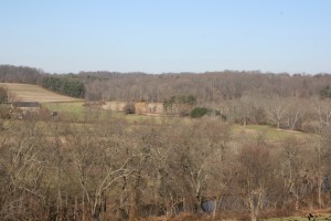
Brinton 1704 House and the surrounding lands were the location of core combat actions in the final phase of the Battle, Chadds Ford, Delaware County
On September 11, 1777, British General William Howe and his professional army engaged General George Washington and his citizen soldiers along the banks of the Brandywine River about 30 miles southwest of Philadelphia. Part of a larger strategy known as the Philadelphia Campaign, the Battle of Brandywine was one of the earliest and largest battles of the American Revolution, encompassing some 30,000 British and American soldiers. The Battle lasted from sunup to sundown, instantly changing the character of a quiet farming community that consisted predominately of Quakers. Although the Battle of Brandywine was a loss for the Americans, they proved that they had the resiliency to withstand the British, increasing French support of the American cause.
Chester and Delaware Counties have a long history of involvement in preservation efforts for the Brandywine Battlefield. Recognizing the need for better planning efforts, the Brandywine Battlefield Task Force (BBTF) was formed in 1993. This organization is a volunteer group of municipal, state, and federal representatives, including both counties, who aim to preserve the national landmark planning area, educate the public, and develop interpretation of the battle and its historic and physical setting. The BBTF has undertaken a number of activities over the years to promote the Battlefield, including tours, brochures, signage, and conservation efforts.
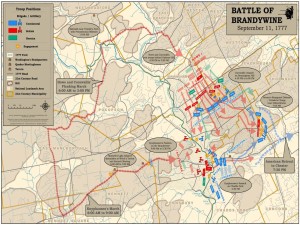
Analysis led to the mapping of the troop movement and positions, Produced by Chester County Planning Commission
Beginning in 2007, Chester County with the assistance of the BBTF and Delaware County undertook a study to reexamine the Battlefield to incorporate a broader understanding of battlefields using a military terrain analysis. This analysis led to the creation of a GIS based animated map of troop movement. In 2011, working with the BBTF, Chester County received an ABPP grant for the completion of a Preservation Plan for the entire 35,000 acre Brandywine Battlefield. This Plan, Brandywine Battlefield Preservation Plan: Revolution in the Peaceful Valley includes chapters on Land Conservation, Historic Resources, Public Access, Interpretation, and Implementation and supports Chester County’s comprehensive policy plan, Landscapes2.
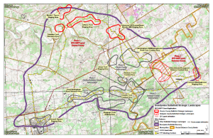
The Brandywine Battlefield Preservation Plan identified 13 strategic landscapes to be the focus of future studies and initiatives. The Chester County Planning Commission (CCPC) and the Delaware County Planning Department (DCPD) have received grants from the American Battlefield Protection Program (ABPP) for the completion of Strategic Preservation Plans for six Brandywine Battlefield Strategic Landscapes: four in Chester County and two in Delaware County. Chester County’s four strategic landscapes represent key areas of Gen. Howe’s Flanking March and include: Martin’s Tavern Staging Area, Trimbles Ford Staging Area, Jefferis Ford Staging Area and OsbourneHill/Strodes Mill Staging Area. Delaware County’s two strategic landscapes focus on the final portion of the battle, the rearguard defense and the retreat. The purpose of these Strategic Landscape Plans is to conduct additional historic research to better understand specific portions of the Battle and to provide focused guidance on how to promote and protect the Battlefield in these areas. Both counties have already begun altering the boundaries of these Strategic Landscapes based upon additional information.
Delaware County is currently conducting additional research on historic resources and on the location of troops in the rearguard movement using historic maps. In addition, DCPD is incorporating the importance of the rearguard and retreat movements in interpretation efforts. CCPC is analyzing damage claims and road papers, to identify what roads existed, to try to more accurately identify the troop’s path. By focusing on smaller planning areas, both counties have been able to conduct more public outreach, which has been met with great appreciation by the public. The project also included hiring a consultant to conduct a geomorphic land study/archeological design study. Both studies are a non-invasive, research-based analysis that will verify and build upon previous planning efforts, including verifying troop locations. Chester County’s consultant will also conduct field investigation.
Both counties are in the process of finalizing research and drafting the document, which should be available to the public in the fall of this year.
Jill Hall is the Senior Planner in the Historic Preservation Division of the Delaware County Planning Department
Karen Marshall is the Heritage Preservation Coordinator for the Chester County Planning Commission
Comment Policy
PHMC welcomes and encourages topic-related comments on this blog. PHMC reserves the right to remove comments that in PHMC’s discretion do not follow participation guidelines.
Commenters and Comments shall be related to the blog post topic and respectful of others who use this site.
Commenters and Comments shall not: use language that is offensive, inflammatory or provocative (this includes, but is not limited to, using profanity, obscene, or vulgar comments); disparage other commenters or people; condone illegal activity; identify the location of known or suspected archeological sites; post personal information in comments such as addresses, phone numbers, e-mail addresses or other contact details, which may relate to you or other individuals; impersonate or falsely claim to represent a person or an organization; make any commercial endorsement or promotion of any product, service or publication.
If you would like to comment on other topics not related to this blog post but related to PHMC, please fill out the PHMC Contact Us Form.
Leave a Reply