We all know that partnerships, collaboration, and teamwork are critical in the effort to identify, preserve, and celebrate Pennsylvania’s historic resources. One such partnership in Philadelphia will help protect the city’s historic places and spaces from the devastating damage caused by natural disasters.
As you may remember from our previous blog posts or the Statewide Conference on Heritage this past July, the Pennsylvania State Historic Preservation Office (PA SHPO) has been working hard over the last year developing their Disaster Planning for Historic Properties Initiative. As part of this initiative, the PA SHPO is engaging in pilot projects in four counties to develop a model framework for the integration of historic property information (inventories, vulnerability assessments, and mitigation actions for particular properties or property types) into the Commonwealth’s county-level FEMA-approved hazard mitigation plans. The four pilot project counties, which include Bedford, Cameron, Monroe, and Philadelphia, will become the first counties in the United States to integrate such information into their hazard mitigation plans. This nationally innovative effort has been made possible by the PA SHPO’s recent $1.5 million award from the U.S. Department of the Interior, National Park Service, in 2014 following Hurricane Sandy.
The pilot project in Philadelphia will focus specifically on flood hazards, the #1 ranking natural hazard threatening life and property. Because Philadelphia is affected by tidal flows due to its location on the Delaware Estuary, the city’s gateway to the Atlantic Ocean, flooding can result from storm surge during tropical storms and sea level rise during high tide.
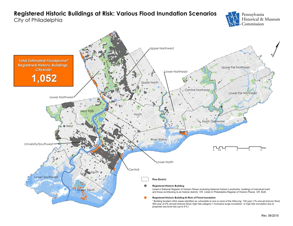 Just how many flood prone, designated historic buildings are there in Philadelphia? A preliminary vulnerability assessment conducted using geographic information systems (GIS) has identified approximately 1,100 historic buildings (those listed individually in the National Register and/or the Philadelphia Register of Historic Places or that contribute to a National Register- or Philadelphia Register-listed historic district) located in one or more of flood hazard areas within the city limits. Many of these resources are not only nationally important landmarks, but are integral to the city’s sense of place and cultural identity.
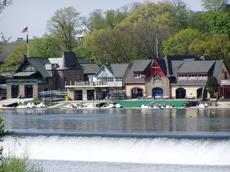
Boat House Row along the banks of the Schuylkill River. Photo by Jeffrey M. Vincour, licensed under the Creative Commons Attribution-Share Alike 3.0 Unported license.
A sample of the historic resources identified in one or more of these flood hazard areas include:
- Boat House Row (National Historic Landmark District; Key # 093849)
- Manayunk Main Street Historic District (National Register Historic District; Key # 000797)
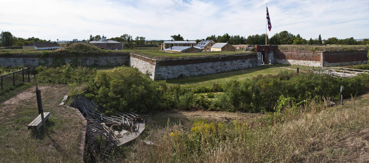
- Fort Mifflin (National Historic Landmark; Key # 001371)
- Ramcat (Schuylkill) Historic District (National Register Historic District; Key # 079900)
- Philadelphia Naval Shipyard (National Register Historic District; Key # 086856)
So, what is this great partnership in Philadelphia, you ask? We are excited to share the news that the U.S. Army Corps of Engineers (USACE) has joined the Philadelphia Office of Emergency Management as a lead partner on PA SHPO’s pilot project in the city of Philadelphia. In addition to the PA SHPO, the team for the pilot project in Philadelphia includes PA SHPO-contracted surveyors and hazard mitigation planners, USACE survey crews, and USACE staff from their National Nonstructural Flood Proofing Committee (NNFPC).
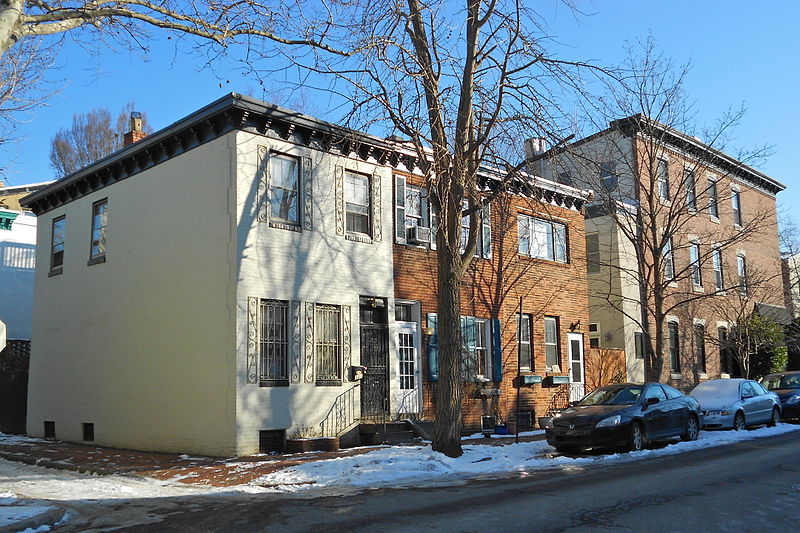
Philadelphia’s Ramcat Historic District around 25th and Pine Streets. Source: Wikimedia Commons.
The scope of the project includes surveying historic properties in selected neighborhoods, analyzing the characteristics of these historic properties that make them more vulnerable to flood damage (like the elevations of basement and first floor openings), and, working specifically with NNFPC, developing sample “nonstructural” floodproofing measures for up to 25 different historic property types found throughout the city, such as the ubiquitous brick row house. Identifying flood-proofing measures and strategies that do not impact, or minimally impact, historic building fabric and provide maximum protection from flooding will provide preservationists, planners, property owners, and local, state, and government agencies in Philadelphia – and throughout Pennsylvania – with the tools necessary to protect the historic properties in their care. In Philadelphia, the resulting strategies will be integrated into the City’s 2017 Hazard Mitigation Plan, thereby becoming eligible for funds from a variety of FEMA grant programs including the Hazard Mitigation Grant Program (HMGP), Flood Mitigation Assistance (FMA), and others. Funds to implement these historic building flood mitigation strategies may also be available from the Keystone Historic Preservation Grant Program.
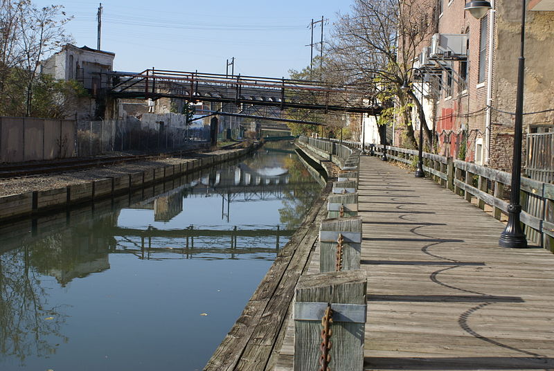
The Manayunk Canal. Photo by J. Clear, licensed under the Creative Commons Attribution-Share Alike 3.0 Unported license..
The survey to collect flood vulnerability information about these and other flood prone, designated historic resources in Philadelphia by the USACE and PA SHPO-contracted survey teams is expected to begin later this fall. Stay tuned for updates on the PA Historic Preservation Office Blog as the project progresses!
Congratulations in getting the funding to protect our nation’s most valuable historic assets. I see you have Key #’s listed. I am looking for how to find these Key #’s on properties here in Pittsburgh, Pa. Any advise as to how I can locate them?
Thanks for the congratulations and the interest in Pennsylvania’s historic resources. You can find all of the information we have available about historic places via the Cultural Resources Geographic Information System (CRGIS) by clicking here: http://crgis.state.pa.us. The system is publicly accessible, free, and does not require a login for access. You can search using the map feature or the AskReGIS function to generate a list of properties in a particular county or municipality. I recommend contacting Bill Callahan, the Community Preservation Coordinator for Western PA at wcallahan@pa.gov if you need further assistance.
Thank you Cory Kegerise for the information. Keep on keeping on in regard to Pennsylvania’s historic resources.