The Pennsylvania Archaeological Data Synthesis: The Beaver Creek Watershed B is a mouthful of words, to say the least.
In my spare time (when I am not acting in my official capacity as a Pennsylvania Department of Transportation [PENNDOT] archaeologist), I am chasing down a four-year-old that needs to work on enunciating his words. If he ever masters the phrase “archaeological data synthesis,” I’ll know my work there is done!
What is an archaeological data synthesis?
It is largely a way to organize and understand a growing data set of archaeological sites and surveys for both professionals and the public.
Archaeologists like to talk about context a lot and the concept and importance of context can range from a local scale with an artifact’s relation to other artifacts or location to a much larger geographic scale, like a watershed.
What is a watershed?
Simply put, a watershed is the area where water from various places collects in one drainage basin.
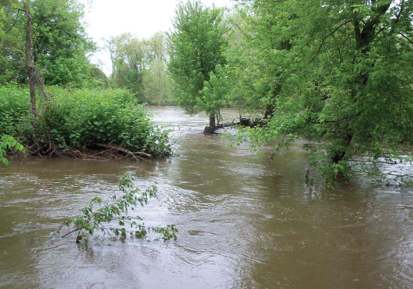
Photograph of the confluence of the Mahoning River and the Shenango River where they form the Beaver River (facing East). White et al. 2011.
In Pennsylvania, the PA SHPO’s Pennsylvania Archaeological Site Survey (PASS) files and digital Cultural Resources Geographic Information System (CRGIS) are organized using the watershed model (McDougal and Funk 2006).
In advance of the replacement of the State Route 0224 State Street Bridge spanning the Mahoning River in Mahoning Township, Lawrence County, Pennsylvania, archaeological investigations conducted from 2009 to 2010 by A.D. Marble and Company resulted in the identification and evaluation of two previously recorded archaeological sites, the Edinburg Site (36LR0003) and the Ashton Cemetery Site (36LR0165) (White et al. 2010).
A subsequent alignment avoided the Edinburg Site (36LR0003); however, impacts to the Ashton Cemetery Site (36LR0165), an archaeological site determined to be eligible for listing in the National Register of Historic Places, could not be avoided. The Federal Highway Administration (FHWA), PENNDOT, PA SHPO, and other consulting parties to the project developed a Programmatic Agreement to mitigate for impacts to the site and development of an archaeological data synthesis for the relevant watershed was part of this agreement.
So what’s in the report?
Archaeologists compiled, summarized, and drew conclusions from 92 individual archaeological site components previously recorded in the Beaver Creek Watershed (Watershed B of the Ohio River Subbasin 20), Beaver and Lawrence Counties (White et al. 2011).
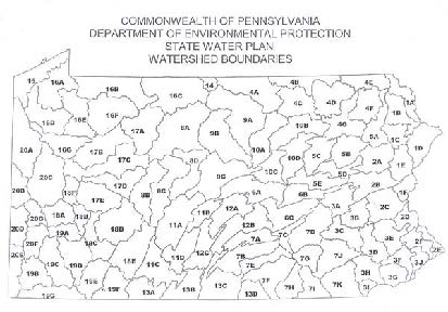
Watershed Boundaries Map (Beaver Creek Watershed: Watershed B of the Ohio River Subbasin 20). White et al. 2011.
Pulling together environmental and locational data alongside the pre-contact cultural resource chronologies, settlement patterns, and even case studies on key sites, several conclusions were reached and summarized.
Specifically, key insights resulting from the Pennsylvania Archaeological Data Synthesis: The Beaver Creek Watershed B (White et al. 2011) included:
- Occupation is reoccupation! Few single component (occupation) sites were identified. Most of the sites in the watershed were locations reused over time by the same and different groups.
- Population sizes fluctuate! While population size is roughly correlated to numbers of previously recorded archaeological sites (which can be problematic as many factors can come into play), population sizes tend to rise and fall throughout prehistoric times.
- Locally Sourced Lithics! Even in prehistoric times, people could be found locally sourcing materials like lithic (stone) used in the production of tools to include areas of glacial deposits, outcroppings and quarrying, as well as river cobble.
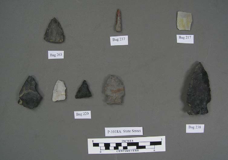
Lithics (Bifaces and tools) recovered from the Ashton Cemetery Site (36LR0165). White et al. 2010.
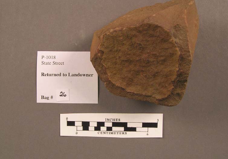
Lithics (Hammerstone) recovered from the Ashton Cemetery Site (36LR0165). White et al. 2010.
Want to learn more?
As is the case with most scientific inquiry, even more research questions were posed! What were they? Check out the results of the research and the research questions (White et al. 2011) to find out.
Curious for more archaeological data synthesis developed for PENNDOT projects? Check out Pennsylvania Archaeological Data Synthesis: The Raccoon Creek Watershed (MacDonald et al. 2003) found here: http://www.paarchaeology.state.pa.us/documents/raccoon_creek.pdf.
References Cited in this post:
MacDonald, Douglas, with Jonathan Lothrop, and David Cremeens.
2003 Pennsylvania Archaeological Data Synthesis: The Raccoon Creek Watershed (Watershed D of the Ohio River Subbasin 20). Report prepared for PennDOT Engineering District 11-0 by GAI Consultants, Inc., Monroeville, Pennsylvania.
McDougal, Steven and Chan Funk
2006 The Watershed Model, Local Contexts, and Settlement Pattern Studies. Paper presented at the (77th) Annual Meeting of the Society for Pennsylvania Archaeology, Washington, Pennsylvania.
White, Richard, with Michael Lenert, Frank Mikolic, and Margaret Sams
2010 Phase I Archaeological Survey and Phase II Evaluation of the Ashton Cemetery Site (36LR0165) Management Summary. Report prepared for PennDOT Engineering District 11-0 by A.D. Marble & Company, Pittsburgh, Pennsylvania.
White, Richard, with Brooke Blades, and Frank Dunsmore
2011 Pennsylvania Archaeological Data Synthesis: The Beaver Creek Watershed (Watershed B of the Ohio River Subbasin 20). Report prepared for PennDOT Engineering District 11-0 by A.D. Marble & Company, Pittsburgh, Pennsylvania.
This week’s post is by guest author, Angela Jaillet-Wentling, a PENNDOT CRP Archaeologist, Districts 11-0 and 12-0.
Angie Jaillet-Wentling is a Historic Preservation Specialist for the Pennsylvania Department of Transportation (PENNDOT) specializing in archaeology. She covers seven counties in southwestern Pennsylvania’s Engineering Districts 11-0 and 12-0. You can reach her at ajailletwe@pa.gov.
Leave a Reply